
iGO Navigation
iGO Navigation screenshots (5)


Description iGO Navigation
Is Offline Navigation Still a Viable Option in a Connected World?
While streaming map services dominate, they introduce dependencies on cellular signal strength and data coverage, which can be problematic in remote areas or during international travel. iGO Navigation addresses this by operating as a fully offline, on-device navigation system. This approach shifts the core computational and data workload entirely to the smartphone, eliminating the need for a constant internet connection for core routing and map display. The application provides a self-contained navigation environment where all vector map data, points of interest, and routing algorithms are stored locally.
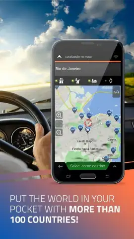
Core Navigation Mechanics and Tools
The application's primary function is turn-by-turn voice-guided navigation using pre-loaded map data. Users input a destination, and the software calculates a route based on configurable criteria such as shortest distance, fastest time, or avoidance of specific road types like tolls or ferries. The interface typically presents a clear, moving map view with upcoming maneuver instructions, remaining distance, and estimated time of arrival. A key operational tool is the comprehensive points of interest (POI) database, which is searchable offline and includes categories like fuel stations, restaurants, and hotels. The system also incorporates speed limit warnings and visual alerts for upcoming speed cameras, where such data is legally available and included in the map package.
Key Functional Advantages
The principal advantage of this software is its operational reliability in areas with poor or no cellular connectivity, ensuring navigation continuity in tunnels, mountain passes, or rural regions. Performance is generally consistent as it is not subject to network latency; route calculation and map rendering speed depend solely on the device's processing power. The user experience is built around predictability, with no surprise data usage charges for map streaming, which can be a significant consideration for travelers. The visual design prioritizes clarity for driving, with day and night mode switching to reduce glare and improve map readability in different lighting conditions.
- Fully Offline Operation: Conducts all routing and map display without requiring an active mobile data or Wi-Fi connection.
- Comprehensive POI Database: Includes a searchable, categorized directory of amenities like parking, gas stations, and restaurants stored on-device.
- Advanced Driver Alerts: Provides visual and audio warnings for posted speed limits and fixed safety camera locations.
We suggest trying iGO Navigation if your travel frequently takes you outside reliable cellular coverage areas or you wish to maintain consistent navigation without data usage.
Disclaimer: This application requires internet access primarily for initial download, map updates, and potential live service subscriptions. Some advanced features like real-time traffic or online search may require a paid subscription or in-app purchase. The app uses locally stored map data; ensure your device has sufficient storage space. Always observe local traffic laws and use hands-free operation while driving. Map data is licensed and may not reflect the most recent road changes without updates.


