
DeepStateMap
DeepStateMap screenshots (3)
Description DeepStateMap
Track Real-Time Conflict Dynamics with Precision Mapping
For analysts, researchers, and observers requiring a factual, detailed overview of military engagements, accessing reliable and granular geospatial data is a constant challenge. DeepStateMap addresses this need directly as a specialized interactive platform, providing a technical visualization of active conflict zones with a focus on operational detail and strategic awareness.
Core Functionality and Analytical Tools
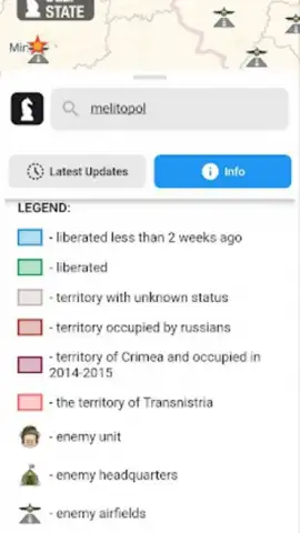
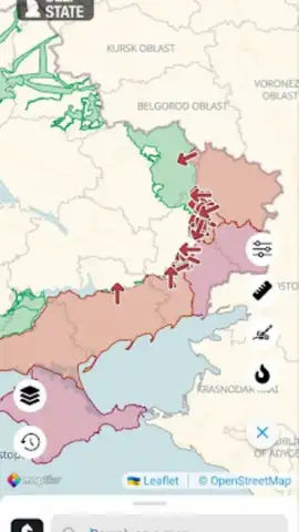
The application functions as a dedicated situational awareness tool, plotting confirmed and reported military data onto a dynamic map interface. It differentiates territorial control through a systematic color-coded and symbol-based legend, categorizing areas as recently liberated, under contested status, or occupied. The platform plots specific Russian military installations, including unit locations, command posts, airfields, naval positions, and strike directions. A key operational feature is the integrated artillery range analysis mode, which allows for the calculation of potential strike distances for systems like HIMARS, M777, and CAESAR along the contact line. This is supplemented by the overlay of NASA FIRMS fire hotspot data, enabling visual cross-referencing of thermal events with frontline positions.
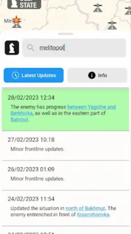
Beyond visualization, the utility includes a direct news feed for contextual updates and a built-in distance measurement tool for tactical assessment between any two points on the map. The architecture supports data caching, allowing for the review of critical map information and saved locations in offline scenarios, ensuring access to intelligence even with intermittent connectivity. The interface is structured for clarity, dividing the theater into distinct, clearly marked zones to facilitate rapid orientation and analysis.
- Interactive Territorial Control Map: Visualizes frontlines with statuses for liberated, contested, and occupied areas, including Crimea, ORDLO, and Transnistria.
- Detailed Military Unit Plotting: Tracks positions of Russian subunits, headquarters, airbases, naval points, and strike vectors.
- Artillery Range Calculator: Features a dedicated mode to analyze firing ranges for specific systems like HIMARS and CAESAR across the frontline.
- NASA FIRMS Fire Data Overlay: Integrates satellite-detected fire hotspots for comparative analysis with current conflict dynamics.
- Offline Data Caching: Enables access to cached map tiles and saved data without an active internet connection for continuous monitoring.
Gain a strategic edge and access the most detailed public-facing conflict map available. Download the mobile app now for exclusive, early access to today's intelligence layer updates. This is a limited-capability release for informed users.
Internet required for live data. IAP available.


