
Nuke Map
Nuke Map screenshots (5)

Description Nuke Map
Visualize the Unthinkable with Precision Mapping
Nuke Map provides a specialized cartographic interface designed for modeling and visualizing the effects of hypothetical nuclear detonations on any geographic location. This analytical tool converts abstract yield data into concrete, layered map overlays, addressing a niche demand for clear, fact-based geographical impact simulation. It serves as a resource for educational analysis, preparedness planning, and geopolitical awareness, transforming complex blast radius and fallout data into an immediately comprehensible visual format.
Core Analytical Features and Interface Mechanics
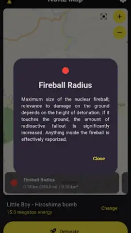
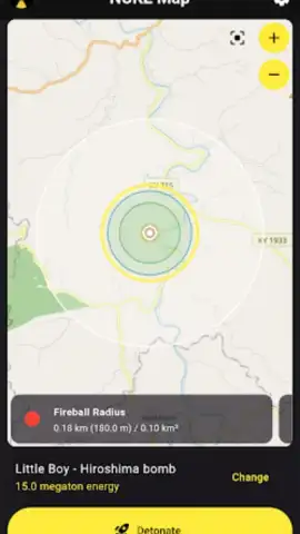
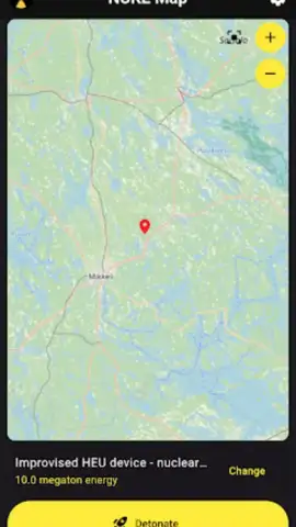
The application's primary function is the placement of a virtual detonation point on an interactive global map, sourced from reliable tile providers. Users can adjust key parameters, including weapon yield—from tactical devices to modern thermonuclear warheads—and select the type of blast effect to visualize, such as thermal radiation radius, shockwave overpressure zone, and approximate fallout dispersion. The interface renders these zones as semi-transparent, color-coded rings and gradients directly over the chosen terrain, allowing for instant scale comparison against real-world landmarks, infrastructure, and population centers. A detailed summary panel provides textual estimates of casualties, structural damage levels, and other blast-related statistics based on the selected parameters and underlying geographical data.
Key Technical and Usability Advantages
- Multi-Layer Effect Visualization: Toggle between fireball, radiation, and pressure wave overlays to understand the distinct phases of a detonation's impact on the mapped environment.
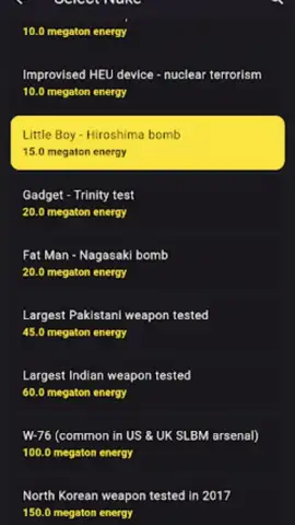
- Customizable Yield and Scenario Input: Model everything from historical bomb yields to custom kiloton/megaton values, with presets for known nuclear devices for rapid comparative analysis.
- High-Resolution Terrain Context: Utilizes detailed base maps to assess impacts relative to specific city layouts, topography, and key points of interest for grounded assessment.
Download the mobile app now to gain exclusive access to this advanced simulation platform. This limited-time offer provides full feature access for all new users.
Requires an internet connection for map data loading. This is a utility application for analytical and educational purposes.


