
NaviMaps
NaviMaps screenshots (16)


Description NaviMaps
Navigating a complex city often feels like solving a puzzle without all the pieces. NaviMaps re-engineers that experience, transforming your smartphone into a precise, context-aware guide that understands not just streets, but the rhythm of daily life in India.
Core Navigation and Mapping Features
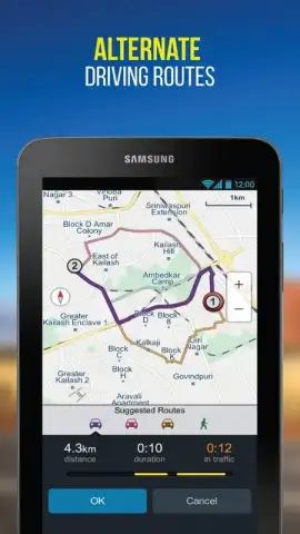
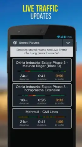
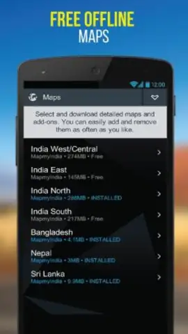
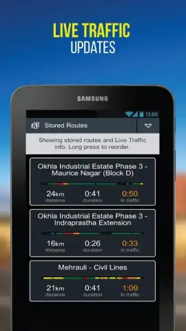
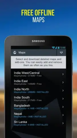
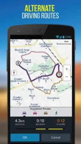
Built on MapmyIndia's authoritative indigenous mapping data, NaviMaps provides a robust alternative to global services, with superior accuracy for Indian addresses, landmarks, and complex road networks. The app delivers reliable turn-by-turn voice-guided navigation for driving, with a strong emphasis on real-time traffic updates, speed camera alerts, and dynamic route optimization to save time. Beyond the car, it offers detailed walking directions and supports multi-modal trip planning. A standout feature is its sophisticated offline functionality; users can download entire state or city maps for full-featured navigation without an active data connection, a critical tool for areas with poor network coverage. The interface integrates live public transit information for major cities and includes practical tools like vehicle-specific routing for trucks, helping to avoid low bridges or weight-restricted roads.
Key User Advantages
The app distinguishes itself through a deeply localized and intuitive user experience. Visuals are clear and utilitarian, with maps that render quickly and respond smoothly to pinch-and-zoom gestures. The voice guidance uses familiar Indian place names and pronunciations, reducing cognitive load while driving. Performance is optimized for a wide range of devices, ensuring stable operation even on older hardware. Perhaps its greatest strength is data sovereignty and privacy; as a homegrown platform, it operates with a nuanced understanding of local geography and user needs that international apps often lack, from accurate pinpoints in dense residential colonies to displaying important local points of interest.
- Authoritative India-Specific Maps: Leverages MapmyIndia's detailed, locally-surveyed maps for unparalleled address accuracy across the country.
- Fully Offline Navigation: Download regional maps for complete, voice-guided turn-by-turn navigation without any mobile data usage.
- Real-Time Traffic Smart Routing: Get dynamic route adjustments based on live traffic conditions, accidents, and road closures.
- Multi-Modal Trip Planner: Seamlessly plan journeys combining driving, walking, and public transit options within a single interface.
- Safety and Alert Systems: Receive proactive alerts for speed cameras, sharp curves, toll plazas, and vehicle-specific road restrictions.
We suggest trying NaviMaps for anyone seeking a reliable, privacy-conscious, and data-efficient navigation tool built specifically for the complexities of Indian roads and cities.
Internet required for initial download and live features. IAP available.


